[ad_1]
As the crisis worsens in Joshimath, with residents being relocated in the aftermath of rapid land subsidence, claims and counterclaims are flying thick and fast.
Two key infrastructure projects are being blamed for the havoc in Joshimath — NTPC Tapovan Vishnugad Hydro Electric Project (HEP) and the Char Dham national highway project. The Union power ministry has come out in support of its wholly owned power generator NTPC, backing its claim that the hydropower project had no role in the land subsidence.
In a letter to the chief secretary of Uttarakhand, Union Power Secretary Alok Kumar said the land subsidence in Joshimath was a very old issue, dating back to 1976, and the construction of the 4×130 megawatt Tapovan Vishnugad HEP started only in 2006 by NTPC. “The project includes the construction of a concrete barrage at Tapovan (15 km upstream of Joshimath town). The head race tunnel (HRT) of the project is not passing under Joshimath town. The tunnel is at a horizontal distance of around 1.1 km away from the outer boundary of Joshimath town and vertically around 1.1 km below the ground level. Construction of the tunnel in this stretch has been done through a tunnel boring machine (TBM), which causes no disturbance to the surrounding rock mass,” read the letter by Kumar.
He added a committee constituted by district magistrate (DM) Chamoli concluded in August 2010 that there was no ground evidence of any instability induced by HRT excavation using TBM. “Construction of the tunnel on this stretch (at over 1 km from Joshimath town) has been completed in August 2011. Construction of the tunnel in rock mass at a depth of around 1 km causes no impact on the surface ground, including flora and fauna. There are no signs of sinking around the tunnel alignment at the overground surface,” Kumar said in his letter.
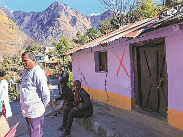
With the ringing of the new year, all hell broke loose in Joshimath as houses developed massive fissures. This was followed by the subsidence of land in the hill town.
Joshimath is situated at 6,000 feet in the Chamoli district of Uttarakhand and is in seismically active Zone V — a region with a high risk of earthquakes. According to the seismic zoning map of the country, Zone V is seismically the most active region and approximately 11 per cent area of the country falls under this category. In any landslide-prone location, construction activities like hydropower and highways make the location more unstable.
Kumar in his letter referenced the MC Mishra Committee and DM Chamoli Committee reports, suggesting several reasons for the crisis — from subsurface seepage erosion by natural drainage to underground saturation resulting from poor sewerage.
Previous flood events aggravated the erosion along the left bank of the Alaknanda river, adversely affecting the stability of the slope on which Joshimath town is situated, the letter said. According to a satellite-based report by the Indian Space Research Organisation, slow subsidence of up to 9 cm has been recorded in Joshimath town for seven months, between April and November 2022 and 5 cm in the past 12 days alone.
At least 15,000 residents in the town are now being relocated. Several hotels are also being dismantled as part of the government’s drive to stabilise the area.
SC to hear subsidence plea on Monday
The Supreme Court is scheduled to hear on Monday a plea seeking the court’s intervention to declare the crisis in Joshimath a national disaster. On January 10, the SC refused an urgent hearing of the plea, saying there are “democratically elected institutions” to deal with the situation.
[ad_2]


